
SpotsWhere to surfCampsTrip planner
Log a session
Surf Scout

Where’s the best place to surf? Skill-graded, honestly reviewed, globally indexed.

Explore
  • Camps & map
  • Best-of guides
  • Where to surf
  • Trip planner
  • Surf & work remotely
  • Surfboard airline fees
  • Board Check
  • Flying with a surfboard
  • Surf Fit Score quiz
Regions
  • Portugal
  • Morocco
  • Bali
  • Costa Rica
  • Sri Lanka
About
  • About
  • Trust & reviews policy
  • How we rate
  • Privacy
  • Analytics choice
  • Terms
  • Photo credits
  • Send feedback
© 2026 Surf Scout. Prototype build.We earn no commission on any link on this site.

Beach break · A-frame

Hiriketiya

South Coast, Sri Lanka

Skill: Levels 3-5
Typical size: 2–6 ft
SpotsWhere to surfCampsTrip plannerBoard CheckQuiz
Surfed here? Log a surf
  1. Map
  2. ›
  3. Sri Lanka
  4. ›
  5. Hiriketiya

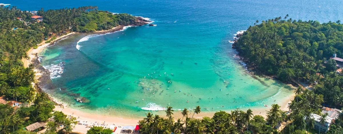
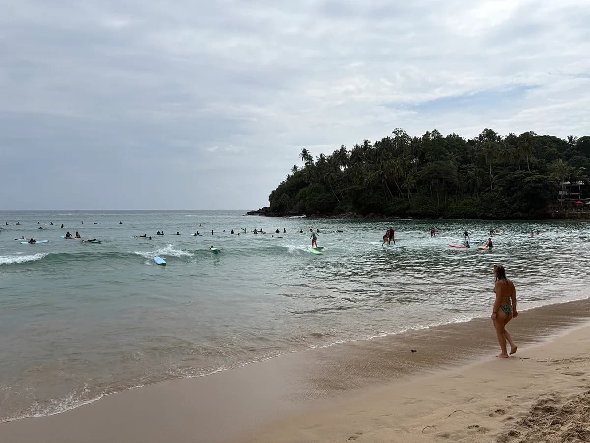
A horseshoe bay with two distinct waves — a punchier right at the east point, and an easier sandbar break in the middle. Tiny in town, big in personality.

Plan a trip here →

Advanced details

The granular read for surfers who want it.

Wave type
Beach break
Bottom
sand+rock
Direction
A-frame
Best swell
S,SW
Best wind
N,NE
Best tide
mid-high
Paddle
2/5
Localism
1/5
Water quality
3/5

Surf report

Live
3/5

Worth a paddle

1 of 2 lined up. Swell suits Hiriketiya, but the tide isn't quite at its best stage.

Next fair window: 23 Nov 2026, 06:30

Live conditions

19:30 (local)
Wave
1.2m
from S
Period? (what does this mean?)Time between waves. Longer period = more powerful, better-organised waves.
10.1s
Swell? (what does this mean?)Waves made by distant storms, smoother and more ordered than the choppy waves a local wind whips up.
1.2m
10s from S
Wind? (what does this mean?)Offshore wind (land to sea) holds waves up and smooths their faces; onshore wind (sea to land) makes them crumble and close out sooner.
5km/h
from NNE
Estimated wave energy? (what does this mean?)How much power each metre of wave front carries (kW/m), worked out from height and period — higher numbers mean waves that push harder.
~7 kW/m(Small)

Calculated by us from the height and period above, not measured — and it describes the swell offshore, not the wave at the break.

Waves from DWD Global WAM, wind from ECMWF IFS, for a model grid point 6 km from the break. Fetched 22 Nov 2026, 17:30. Times on this card are local to Hiriketiya. Weather data by Open-Meteo.com, licensed CC BY 4.0. Not a suitability or safety assessment — check local conditions and ask your instructor.

medium period.

Why
✓
Swell
best: S,SW
—
Wind? (what does this mean?)Wind blowing roughly along the coastline rather than from the land or the sea. Less help and less harm than a head-on offshore or onshore wind.
best: N,NE
~
Tide? (what does this mean?)Where the sea sits in that day's own rise and fall — low, mid or high for THIS spot and THIS day, not a fixed height everywhere shares.
best: mid-high

Next 7 days

The best-rated window in the cached forecast.

Best day this week · Today (22 Nov)
3/5Worth a paddle
1.2–1.2m10s period swell from S5km/h windfrom NNE

This is the week's best-rated wave quality, not a suitability call. Take the 2-minute quiz to see how Hiriketiya fits your level.

Surf outlook

Today’s call (
our estimate? (what does this mean?)A 1-5 score of how organised the waves look, from forecast height, period and wind speed — it rates the waves, not whether they fit your ability.
)
3/5Worth a paddle

Sunrise around 05:58, sunset around 17:48 today.

Mon’s call (
our estimate? (what does this mean?)A 1-5 score of how organised the waves look, from forecast height, period and wind speed — it rates the waves, not whether they fit your ability.
)
3/5Worth a paddle

Sunrise around 05:58, sunset around 17:48 on Mon.

Tue’s call (
our estimate? (what does this mean?)A 1-5 score of how organised the waves look, from forecast height, period and wind speed — it rates the waves, not whether they fit your ability.
)
3/5Worth a paddle

Sunrise around 05:59, sunset around 17:48 on Tue.

Wed’s call (
our estimate? (what does this mean?)A 1-5 score of how organised the waves look, from forecast height, period and wind speed — it rates the waves, not whether they fit your ability.
)
3/5Worth a paddle

Sunrise around 05:59, sunset around 17:48 on Wed.

Thu’s call (
our estimate? (what does this mean?)A 1-5 score of how organised the waves look, from forecast height, period and wind speed — it rates the waves, not whether they fit your ability.
)
3/5Worth a paddle

Sunrise around 06:00, sunset around 17:48 on Thu.

Fri’s call (
our estimate? (what does this mean?)A 1-5 score of how organised the waves look, from forecast height, period and wind speed — it rates the waves, not whether they fit your ability.
)
3/5Worth a paddle

Sunrise around 06:00, sunset around 17:49 on Fri.

Sat’s call (
our estimate? (what does this mean?)A 1-5 score of how organised the waves look, from forecast height, period and wind speed — it rates the waves, not whether they fit your ability.
)
2/5Barely worth it

Sunrise around 06:00, sunset around 17:49 on Sat.

Tide todayHigh around 00:30 (+0.8m)Low around 06:30 (+0.3m)High around 12:30 (+0.7m)Low around 18:30 (+0.3m)
nowHigh 00:30+0.8mLow 06:30+0.3mHigh 12:30+0.7mLow 18:30+0.3m
Model estimate (MeteoFrance SMOC), heights relative to
mean sea level? (what does this mean?)The long-run average height of the sea surface — tide heights are metres above (+) or below (−) that average.
, times approximate — not a tide table and not for navigation.
Tide MonHigh around 00:30 (+0.8m)Low around 07:30 (+0.3m)High around 13:30 (+0.7m)Low around 18:30 (+0.3m)
High 00:30+0.8mLow 07:30+0.3mHigh 13:30+0.7mLow 18:30+0.3m
Model estimate (MeteoFrance SMOC), heights relative to
mean sea level? (what does this mean?)The long-run average height of the sea surface — tide heights are metres above (+) or below (−) that average.
, times approximate — not a tide table and not for navigation.
Tide TueHigh around 01:30 (+0.8m)Low around 07:30 (+0.2m)High around 13:30 (+0.7m)Low around 19:30 (+0.3m)
High 01:30+0.8mLow 07:30+0.2mHigh 13:30+0.7mLow 19:30+0.3m
Model estimate (MeteoFrance SMOC), heights relative to
mean sea level? (what does this mean?)The long-run average height of the sea surface — tide heights are metres above (+) or below (−) that average.
, times approximate — not a tide table and not for navigation.
Tide WedHigh around 01:30 (+0.8m)Low around 08:30 (+0.2m)High around 14:30 (+0.7m)Low around 20:30 (+0.3m)
High 01:30+0.8mLow 08:30+0.2mHigh 14:30+0.7mLow 20:30+0.3m
Model estimate (MeteoFrance SMOC), heights relative to
mean sea level? (what does this mean?)The long-run average height of the sea surface — tide heights are metres above (+) or below (−) that average.
, times approximate — not a tide table and not for navigation.
Tide ThuHigh around 02:30 (+0.8m)Low around 08:30 (+0.2m)High around 14:30 (+0.7m)Low around 20:30 (+0.3m)
High 02:30+0.8mLow 08:30+0.2mHigh 14:30+0.7mLow 20:30+0.3m
Model estimate (MeteoFrance SMOC), heights relative to
mean sea level? (what does this mean?)The long-run average height of the sea surface — tide heights are metres above (+) or below (−) that average.
, times approximate — not a tide table and not for navigation.
Tide FriHigh around 02:30 (+0.7m)Low around 09:30 (+0.2m)High around 15:30 (+0.6m)Low around 21:30 (+0.3m)
High 02:30+0.7mLow 09:30+0.2mHigh 15:30+0.6mLow 21:30+0.3m
Model estimate (MeteoFrance SMOC), heights relative to
mean sea level? (what does this mean?)The long-run average height of the sea surface — tide heights are metres above (+) or below (−) that average.
, times approximate — not a tide table and not for navigation.
Tide SatHigh around 03:30 (+0.7m)Low around 10:30 (+0.2m)High around 16:30 (+0.6m)Low around 21:30 (+0.3m)
High 03:30+0.7mLow 10:30+0.2mHigh 16:30+0.6mLow 21:30+0.3m
Model estimate (MeteoFrance SMOC), heights relative to
mean sea level? (what does this mean?)The long-run average height of the sea surface — tide heights are metres above (+) or below (−) that average.
, times approximate — not a tide table and not for navigation.

Times on this card are local to Hiriketiya. The star call is our own estimate, calculated from the forecast height, period and wind speed — not measured, and not a suitability or safety assessment. How we rate explains the scale. Weather data by Open-Meteo.com, licensed CC BY 4.0. Fetched 22 Nov 2026, 17:30.

Surf Snapshot

Estimated seasonal guidance — not a live forecast.

Nov
Consistency this monthEstimated
Moderate
Beginner safety
Use caution
Crowd
Crowded
Water quality
Good
Typical size: Waist-to-overhead (2-6 ft)Boardshorts
Recommended boardsShortboardMidFish
Year-round consistency
Nov: Moderate consistencyTap a month

Quick answers about Hiriketiya

Where is Hiriketiya?

Hiriketiya is in South Coast, Sri Lanka.

What level is Hiriketiya for?

Hiriketiya suits Levels 3-5 surfers.

When is surf most consistent at Hiriketiya?

Our seasonality estimates put Hiriketiya's most consistent surf in Dec–Feb · Apr. This is seasonal guidance, not a live forecast.

  • Peak consistency rating: High (on our 0-5 scale).

When to surf Hiriketiya, month by month

Estimated from our authored seasonality — not a live forecast.

Peak season: Jan, Feb, Apr, Dec (High).

Month-by-month surf consistency and wetsuit guidance for Hiriketiya
MonthSurf consistencyWetsuit
JanpeakHighBoardshorts
FebpeakHighBoardshorts
MarModerateBoardshorts
AprpeakHighBoardshorts
MayInconsistentBoardshorts
JunRareBoardshorts
JulyRareBoardshorts
AugRareBoardshorts
SeptRareBoardshorts
OctInconsistentBoardshorts
NovModerateBoardshorts
DecpeakHighBoardshorts

Does this wave fit your level?

Rated for Levels 3-5 · Best at Level 4.

Take the 2-minute quiz to see if Hiriketiya fits you today.

Find my Level →

Beginner notes

Surf the middle, not the points. The points are short, fast, and the take-off zone gets contested.

Hazards

  • rocks at the points
  • crowd

Camps near Hiriketiya

Hiriketiya
Kima Surf Hiriketiya

Kima Surf Hiriketiya

$$
Hiriketiya, Sri Lanka
Not enough reviews yet
Levels 1-5Early signal Surf lessons Stay on site🌊2 surfs/day included
Nov · Moderate consistency · Waist-to-overhead
Boardshorts · Shortboard · Mid
From US$364 / week · room type not confirmed
Ahangama
Soul & Surf Sri Lanka

Soul & Surf Sri Lanka

$$$
Ahangama, Sri Lanka
Not enough reviews yet
Levels 2-5No signal yet Surf lessons Stay on site
Nov · Moderate consistency · Waist-to-overhead
Boardshorts · Shortboard · Mid
From US$980 / week · room type not confirmed

Nearby spots

The closest graded spots to Hiriketiya, straight-line distance.

  • Mirissa~28 km · Levels 2-5
  • Weligama Bay~31 km · Levels 1-4
  • Midigama~35 km · Levels 3-6
  • Ahangama~38 km · Levels 3-5
  • The Rock, Kabalana~40 km · Levels 4-6

Best months to surf here

In-season months for Sri Lanka, from our editors’ season calendar.

  • Jan
  • Feb
  • Mar
  • Apr
  • Nov
  • Dec

How this spot is sourced

Cross-checked against 2 sources from 2 independent lineages, last checked August 2026.

Two or more independent sources agree on exact position.

  • OpenStreetMap
  • Surf-Forecast.com

On the map